
TROPICAL WEATHER UPDATES
Estimated reading time: 3 minutes
Atlantic and Caribbean Tropical Weather Forecast Map
Stay updated with the latest tropical weather forecast for the Atlantic Ocean and Caribbean Sea. Furthermore, if you see a disturbed area marked in orange or red, it’s crucial to monitor the development of this tropical system regularly, as these colors indicate potential for intensification. In addition, check this map frequently for any changes in tropical storm formation and preparedness alerts, so you can respond promptly to any updates
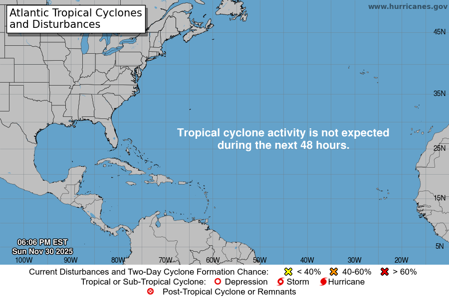
Graphic material provided by: National Hurricane Center
Tropical Weather Coverage
 Current Caribbean Weather Update: No Tropical Cyclones Detected
Days to start hurricane season 2025
Hurricane season 2025 travel alerts
Stay informed with our free travel alert service covering Cancun and the Riviera Maya region from June 1 to November 30, 2025.

Important Tropical Cyclone Advisory
This information is provided for general awareness only; however, in the event of a potential tropical cyclone, it is essential to prioritize your safety. Therefore, avoid actions that could put you at risk, and instead, focus on following official guidance and safety protocols. Always rely on guidance from official state government sources, especially when making crucial decisions related to tropical weather events. Additionally, staying informed through trusted channels can ensure you have the most accurate and up-to-date information.
This bulletin is active only during the official Hurricane Season. If a tropical disturbance arises outside of this period, the bulletin will be reactivated with the latest updates to ensure timely information on storm activity.
Tropical Weather Bulletin by the National Hurricane Center
ATLANTIC OCEAN & CARIBBEAN SEA
ABNT20 KNHC 061733
YUCATAN & QUINTANA ROO, MEXICO

Tropical Weather Outlook
NWS National Hurricane Center Miami FL
200 PM EDT Tue Oct 6 2026

For the North Atlantic...Caribbean Sea and the Gulf of America:

Southwestern Gulf of America (AL92):
Satellite images and surface observations indicate that showers and
thunderstorms are becoming better organized while surface pressures
are gradually falling. If these trends continue, advisories will
likely be issued on this system later today or tonight while it
moves slowly eastward. The low pressure area could bring gusty winds
and areas of heavy rain to the western portions of the Yucatan
Peninsula of Mexico in a couple of days.

The disturbance is expected to turn to the north or northeast toward
the northern Gulf Coast by the end of the week. It is still too
early to determine specific impacts to the northern Gulf Coast, but
interests from the Florida Panhandle to Louisiana should closely
monitor the progress of this system. The NOAA Gulfstream jet is en
route to sample the environment over the Gulf this afternoon and Air
Force and NOAA reconnaissance aircraft are scheduled to investigate
the system tomorrow.
* Formation chance through 48 hours...high...near 100 percent.
* Formation chance through 7 days...high...near 100 percent.


Forecaster Cangialosi
Caribbean Sea Seven-Day Weather Forecast: Track Tropical Systems
Click the play button to view the Caribbean’s seven-day current forecast. As you watch, swirling motions will highlight potential tropical systems in the region. Additionally, you can drag the image to explore different areas, and, for even more detailed tracking, use the + and – buttons to zoom in. Keep in mind that Windy.com uses different models than the NHC to forecast storm tracks. You may notice a discrepancy between the predicted paths.
Images and information of: National Hurricane Center :::: Servicio Meteorologico Nacional (Mexico) ::: Cancun Radar
Posts Related: 5 day Cancun Weather Forecast
Related Content
Plase share this post: